
Upper Dolpa Trek
UPPER DOLPO TREK
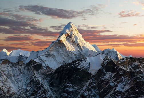
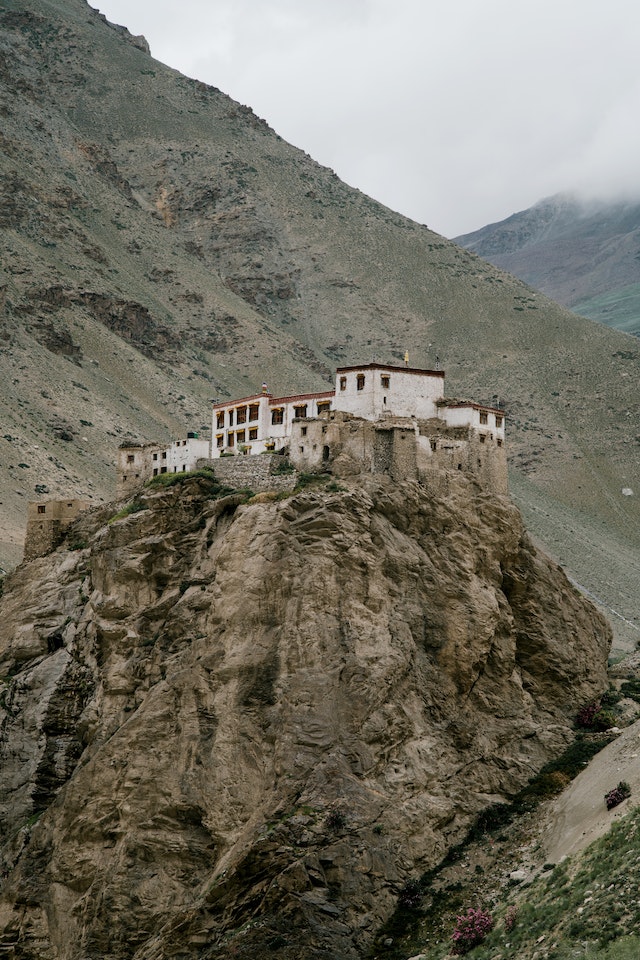
The Upper Dolpo Trek is an adventurous trek in western Nepal's remote, unspoiled landscape, close to the Nepal-Tibet border. The vast and remote Karnali region is rich in both natural resources and culture. By going on a trek to Upper Dolpo, you can see into the lives of the people who live there and explore remote areas. The Upper Dolpo district actually follows the old pre-Buddhist Bon-Po religion. The Upper Dolpo is encircled by the Dhaulagiri massif to the south-east. The weather changes as you go uphill, and the scenery also changes as we get closer to the white snow-capped mountains. Dolpo lets you experience nature in its most basic form. Yaks, mules, and horses are the only means of transportation for the entire district. The upper Dolpo region lacks roads. If you want to see Upper Dolpo, you can only do so by trekking. You'll begin to hear prayers humming from the monuments and flags fluttering as you approach the Upper Dolpo. The trek will eventually come to an end at the Lower Mustang, where you will walk through lush pastures and fresh, crystal-clear glacial lakes.
You can travel to the mysterious land of Dolpo, home to magnificent peaks, on this short excursion. The trek itself is made more exciting by its remote location. The journey passes numerous fantastic and remarkable sights: turquoise Shey Phoksundo Lake (the most profound pool of Nepal), cold high passes, stowed away valleys, the Shey Gomba religious community, dazzling perspective on Mt. Kanjirowa and sacred Precious stone Mountain.
Its path additionally goes through gorgeous valleys, intriguing spots, nearby settlements and plant life woodland of pines, Rhododendrons, Oaks and so on. Summer or the monsoon are the best times to undertake this trek. Winters should be avoided because of the heavy snowfall they bring.
UPPER DOLPO TREK
Trip Itinerary
-
1Fly to Nepalgunj from Kathmandu
As per the flight schedule we transfer to the domestic airport for one and half hour wonderful flight to Nepalgunj. After reaching, we’ll have time in the late afternoon or evening to explore the town which is situated on the south-west Nepal border with India. Here the temperature is warm and temperate.
Meals B/BHighlights Fly to Nepalgunj from KathmanduAccommodation HOTEL -
2Fly to Juphal from Nepalgunj and walk to Dunai
After a pleasant overnight at Nepalgunj, we take early morning flight to Juphal of about 45 minutes over the Himalayan foothills, with views of Annapurna and Dhaulagiri peaks to the north. After arriving at Juphal, a short walk leads to our overnight camp at Dunai village.
Meals B,L,DHighlights Fly to Juphal from Nepalgunj and walk to DunaiAccommodation HOTEL -
3Dunai to Chhepka
We begin the trek descending down through the streets of Dunai Town to cross the bridge over Bheri River. Then we chase the northern bank of the river for an hour to reach Sulighat and head north to reach Shey Phoksundo National Park Check Post. Beyond the check-post, we gradually climb up along the rocky trail that lies above the Suli Ghad Khola. As the trail stretches higher through the series of hemp trees, we arrive to Kageni. Further trekking through beautiful tropical forest of walnut and maple trees, we begin to see the first glimpses of Tibetan culture. Cherishing the views of fluttering prayer flags, floral and faunal biodiversity, cascading waterfalls and lush vegetation we arrive to the village of Shyanta 2520m. Almost one and half hour of uphill trek from Shyanta along the narrow trail brings us to overnight stay at Chhepka 2670m.
Meals B,L,DHighlights Dunai to ChhepkaAccommodation TEA HOUSE/LODGE -
4Chhepka to Chunuwar
Today the path goes through beautiful pine forests, with some bushes, birches and other broadleaf trees mixed in as well. The road follows the river upstream through dense forests. On the way you encounter local people with their mules or dzopas (crossbreed between yak and cow) loaded with things to sell. The path continues at the other side of the bridge. It’s two hours more to Chunuwar. Close to Chunuwar you can find the Amchi Hospital. An Amchi is a doctor who is educated in traditional Tibetan medicine, and always is a lama (monk) as well. After a walk, we reach our Camping Chunuwar.
Meals B,L,DHighlights Chhepka to ChunuwarAccommodation TEA HOUSE/LODGE -
5Chunuwar to Phoksundo Lake
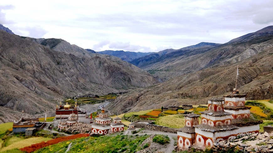
It’s a short hike today to the Phoksundo Lake. It includes a long and sometimes steep climb of about 2 hours. Here the river is left behind and you follow the path high above the water. Climb up to a ridge, about 3,875meters, from where you will have the most staggering views of a 300meters waterfall, the highest in Nepal, and your first view of Phoksundo Lake, a study in turquoise. The path is going down till it gets close to the river, which you follow until you reach the picturesque settlement of Ringmo with its mud plastered chortens and mani walls. From the settlement it is a short walk to the shores of Phoksundo Lake where you set up camp. This lake is of a stunning beauty. It has an enchanting deep blue color and is emerald green close to the shore. Steep cliffs and snowcapped mountains surround the lake.
Meals B,L,DHighlights Chunuwar to Phoksundo LakeAccommodation TEA HOUSE/LODGE -
6Phoksundo Lake- Rest day
Today will be a well-deserved rest day for acclimatization at Phoksundo Lake. During the day we can explore Ringmo Village and head to Tshowa (the lake-shore Bon Monastery). Then we drop down to Phoksundo Lake along steep-sided cliffs. The lake is famous for its magnificent turquoise color and spectacular scenery. Many beautiful glaciers can be found near and above the lake area. There are many monasteries (Gompas) and Bon-po religious sites at the park and we spend our time visiting some of these. We also explore the wonderful natural sites and enjoy our nature tour.
Meals B,L,DHighlights Phoksundo Lake- Rest dayAccommodation TEA HOUSE/LODGE -
7Phoksundo lake to Sallaghari
This day, we will enter restricted area of Upper Dolpo. It climbs along the narrow trail cut on a cliff standing vertically straight above Phoksundo Lake. This treacherously fascinating trail brings us to another side of Phoksundo Lake. This trail is used by peoples of Dolpo and other trade with Tibetans. Ti is really adventurous to pass through the trail. When we reach the top, we will have beautiful view of Lane Ringmo, the dark green pine forests and snowcapped mountain to the South. We will have to descend first and ascend through a wide valley which will offer spectacular view of Kanjirowa Himal (6612m) then we will reach an alpine area with junipers called Thaneba or Lake side camp, a beautiful place of camping. Enjoy the night in the camps amongst beautiful pine forest.
Meals B,L,DHighlights Phoksundo lake to SallaghariAccommodation TEA HOUSE/LODE -
8Sallaghari to Nangdala HC
Today’s trek is relatively short; we trek for almost three hours to reach Kangla/Nangdala Base Camp 4100m. As the trek begins, we ascend up the narrow defile of Tuk Kyaksa River. The trail switches to opposite side of the river several times. Soon we arrive to a place where the rapids of the river are calmer. We cross the bridge over the river at that point. Thirty minutes of walk after the bridge, we come across the wide valley followed by two hours of walk along the canyon brings us the potential campsite. A walk for a while further reaches to the massive rock slab, which is Kang La/Nangdala Base Camp- our campsite for the night.
Meals B,L,DHighlights Sallaghari to Nangdala HCAccommodation TEA HOUSE/LODGE -
9Nangdala HC to Shey Gompa via Nangdala pass (5240M)
As the day start, we trek to the renowned Shey Gompa and the nearby 'Crystal Mountain', the most sacred peak in Dolpo which Dolpo pilgrims circumambulate each summer before the harvest. We are now entering the real Dolpo, and to enter into this mystical land we have to cross the Kangla/Nangdala pass. We trek for continuous three hours along the graveled trail uphill to reach the top of Kang La/Nangdala Pass. However, rewards of all the efforts is the eye feast views from the Kang La Pass includes Crystal Mountain, the mountains in Tibetan territory and the mesmerizing landscapes of Dolpo. We also have views of the peaks Shey Shikkar and Kang Chunne, both just over 6000 meters, before descending steeply down to the valley floor and along the river. A red chorten marks the entrance to Shey. We camp for the night.
Meals B,L,DHighlights Nangdala HC to Shey Gompa via Nangdala pass (5240M)Accommodation TEA HOUSE/LODGE -
10Shey Gompa to Namgong Gompa via Shey La pass (5240M)
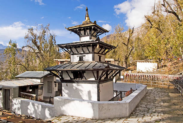
Today we will explore Shey Gompa. The monastery is locally known as Shelri Sumdho Gompa. Shey Festival, the summer festival observed by the people of Dolpo with huge enthusiasm is hosted at Shey Gompa. After exploring the Shey Gompa, it follows the trail beside Sephu Khola for almost couple of hours. The landscapes during this part of the trek are typical Dolpo landscapes- barren and enchanting. Then we begin to climb up towards the top of Shey La Pass, which is almost two hours of hike. The peak of Shey La Pass west of Shey, rewards us with the magnificent views of Mustang to the East, Tibet to the North and Kanjiroba, Kagmara and Riu Dhukta, or the Crystal Mountain, to the West. The final push downhill from the pass, which is almost 2 hours of hike brings us to Namgong. We spend our night at Namgong.
Meals B,L,DHighlights Shey Gompa to Namgong Gompa via Shey La pass (5240M)Accommodation TEA HOUSE/LODGE -
11Namgong Gompa to Saldang
Our Trek to Saldang starts with climbing a tree slope. We have to ascend to 4700m before going down steep slopes to picturesque village of Saldang, situated on a plateau high above the Namga Khola (river) and the biggest villages of lower Dolpo area. Saldang is a beautiful village with lots of dry land surrounded hills. The village is prosperous, not only agriculturally but also for its strategic location on a trade route to Tibet. Amchi tradition and Buddhism in Dolpo thrives here at Saldang. We'll get a chance to visit some local houses, drink some salt butter tea or chhyang (Tibetan barley beer) and sample the local fare at Saldang.
Meals B,L,DHighlights Namgong Gompa to SaldangAccommodation TEA HOUSE/LODGE -
12Hike to Yangjer Gumba (4599M) & Back to Saldang
From Saldang, we walk further north along the Namga Khola (river) on a wild and barren terrain. We begin our walk on a fairly gradual path with few ups and downs. On the way, we pass through Marang and Ki villages. Next, we cross a tributary of Panzang River and walk towards the east and cross the river again before reaching Yangjer Gumba which houses an old Bon-Po Monastery. Explore Yanger Gumba and return back to Saldang. Overnight in Saldang.
Meals B,L,DHighlights Hike to Yangjer Gumba (4599M) & Back to SaldangAccommodation TEA HOUSE/LODGE -
13Saldang to Khoma Village
Today we will walk for six hours and reach the village of Komash. Initially, the trail follows the Saldang Lek along the Rapyha Khola to the barren hillside. Exiting out to the elevated ridge (Khom La) of almost 4500m, the trail descends down steeply to Komash Village a village which bears similarity to a Tibetan village. Overnight at Komash.
Meals B,L,DHighlights Saldang to Khoma VillageAccommodation TEA HOUSE/LODGE -
14Khoma Village to Shimen
As we start our trek from Komash village we walk through the forest where we may sight some endangered animals like snow leopard or Blue sheep. On the way we pass small villages. The landscapes in the vicinity is full of highland deserts with few shrubs like vegetation. After almost five hours of comfortable hike we arrive to Shimen. Overnight at Shimen.
Meals B,L,DHighlights Khoma Village to ShimenAccommodation TEA HOUSE/LODGE -
15Shimen to Tinje
Today the trail goes by the side of Panjyang Khola. There are some villages and gompas on the way to Tinje. We can visit some gompas and explores some villages. Tinje is a very beautiful valley. There is a natural air strip where once a British aircraft had landed and taken off.
Meals B,L,DHighlights Shimen to TinjeAccommodation TEA HOUSE/LODGE -
16Tinje to Yakkharka
From the village of Tinje we start our trek to Yak Kharka. Initially the trail to Yak Kharka chases the trail beside Panjyan River to the small settlement of Chhamdang. Beyond it the trek along the river bank continues to the convergence of Chholtam Khola and Panjyan Khola. Trekking further we cross the bridge over Thalum Khola, which flows from Thalum Lek and arrive at Yak Kharka. Yak Kharka is an open grazing ground for yaks and sheep. The grassy meadow of Yak Kharka makes for an excellent camping site.
Meals B,L,DHighlights Tinje to YakkharkaAccommodation TEA HOUSE/LODGE -
17Yakkharka to Chharka via Mola pass (5030M)
From yak kharka we trek towards Chharka. Crossing the pass Mola (5030m) we reach Chharka. We can have an amalgam view of the local culture, visit beautiful village and the Bon Monastery in Chharka.
Meals B,L,DHighlights Yakkharka to Chharka via Mola pass (5030M)Accommodation TEA HOUSE/LODGE -
18Chharka village to Norbulung Nulungsumda
Today the trail goes through the arid high land. There are some up hills on the way. We trek up to Norbulung and have a night camp there.
Meals B,L,DHighlights Chharka village to Norbulung NulungsumdaAccommodation TEA HOUSE/LODGE -
19Norbulung to Ghalden Ghuldum via Niwala pass (5120) & Jungbenla pass ( 5550M)
From Nulungsumda ascending trail takes us to the pass Niwas La. Crossing the pass the trail we again proceed towards another pass Jungbenla then the trail goes downhill up to Ghaldang Ghuldung, where we make the night stop.
Meals B,L,DHighlights Norbulung to Ghalden Ghuldum via Niwala pass (5120) & Jungbenla pass ( 5550M)Accommodation TEA HOUSE/LODGE -
20Ghalden Ghuldum to Sangta
Today the trail goes with several ups and downs and finally reaches to the village Sangta.
Meals B,L,DHighlights Ghalden Ghuldum to SangtaAccommodation TEA HOUSE/LODGE -
21Sangta to Phalyak
We climb the hill behind Sangta and spent most of the day making a high traverse, crossing nine ridges to a final crest at 4280m. We then descend into the Kali Gandaki valley, traversing under high cliffs and descending to the large village of Phalek.
Meals B,L,DHighlights Sangta to PhalyakAccommodation TEA HOUSE/LODGE -
22Phalyak to Jomsom
We climb to a ridge at 3360m and make a final descent on a challenging trail of loose rocks to Jomsom at 2670m. Jomsom is also one of the famous places for the tourist.
Meals B,L,DHighlights Phalyak to JomsomAccommodation HOTEL -
23Jomsom to Pokhara by FLY
We fly from Jomsom to Pokhara today. We can arrange a flight to Kathmandu too in the same day. We will receive you at Kathmandu airport and transfer you to the hotel.
Meals B/BHighlights Jomsom to Pokhara by FLYAccommodation HOTEL
Included:
- Arrival/Departure
- 1 day tour in Kathmandu
- All Private transport
- KTM-Nepalgunj- Juphal by flight
- Jomsom-PKR by flight
- Guide for all tour/Trek
- Hotel in Kathmandu & Pokhara
- All meals in trekking
- Porters
- Tea house Accommodation & Some place camping trek
- All permits (Restricted area permits)
Excluded:
- Travel Insurance
- Meals at Kathmandu
- Tipping
- Personal equipment
- International flight
Reviews
This package has no review yet!Add Your Review
12 travellers are considering this tour right now!


.jpg)